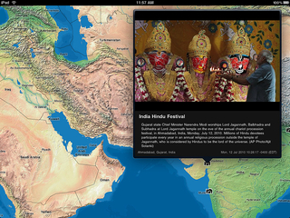
I pursued this internal AP project in order to learn iOS development. The project experimented with end-to-end technology: A server-side OS X application accessing the AP photo feed and delivering it to an iOS client app with a custom map component.
The server software read the AP NNTP photo feed that it publishes to members. My software:
- Created an XML feed of the content.
- Resized photo assets.
- Geolocated photos from textual metadata content.
Simultaneously, I wrote the iPad client app to:
- Read the feed.
- Write a network manager class to handle asset loading.
- Create a custom map component.
- Design and implement a simple but usable interface.
The map component was not based on Google Maps or the built-in iOS map viewer. It is a UIScrollView subclass—this was a great opportunity to learn how to use that class’s zoom ability. My map component:
- Is tile-based with three levels of zoom.
- Uses designed map tiles that I created in ArcGIS, Adobe Illustrator, and Adobe Photoshop.
- Supports coordinate projection transformation and plotting.


