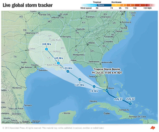
The development of the new AP storm tracking interactive and its underlying map engine involved coordination with the primary data provider and research into competing storm tracking products.
- Map engine is tile based and supports multiple zoom levels.
- Map engine supports coordinate projection transformation for creating dynamic overlays based on Lat-Lon data.
- Map imagery was provided by Natural Earth in equirectangular projection; I wrote a tool to project that map imagery to the spherical Mercator format and then create tile sets.
- I created separate data layers for each zoom level in ArcGIS.
- Additional tools were developed to generate cloud overlays from satellite sources, but we ultimately decided against implementation for editorial reasons.
- Weather data is obtained from an XML feed.
The interactive went through rigorous testing due to the life-and-death nature of the content. During this process I found a discrepancy with the Cone of Uncertainty my software was calculating, which resulted in a data provider finding and correcting the underlying error on their maps.


